Glacier Loss:
In 1984 as the project began the goal was selecting glaciers across varied regions of the North Cascades. Four of our key field areas have experienced signficant glacier loss, with 25 mapped glaciers in 1984 having disappeared by the end of 2023. Glacier loss is indicated here using in each case a Sentinel image from September 2023 is annotated with existing glaciers in white and glaciers lost since 1984 in yellow. This is paired with a Global Land Ice Measurements from Space (GLIMS) map of glacier extents. We still work in the three first field locations every summer, while the Rainy Pass area was discontinued after the loss of Lewis and Lyall Glacier.
Monte Cristo
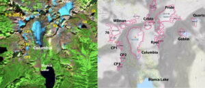
The existing glaciers are shown in white in the 2023 Sentinel image at left, while glaciers that have disappeared are in yellow, and at right is the GLIMS map of the area, showing mapped glacier area. Columbia Peak 1/2/3=CP!/CP2/CP3, KY=Kyes, CR=Cristo, Goblin=GL, Quartz=QL are gone. Columbia, 76, Pride and Wilman Glacier all remain.
The focus of our work in this area is Columbia Glacier, a World Glacier Monitoring Service (WGMS) reference glacier. Working on this glacier each of the last 40 years we have observed its decline and the loss of most of the small glaciers in the area nearby that are also in the Skykomish Watershed. In 1984 the Blanca :Lake basin there were five small glaciers below Columbia Peak, Kyes Peak and Monte Cristo Peak, as of 2023 all are gone. In the next basin to the east also feeding the Skykomish Glacier the avalache fed glaciers at Goblin Lake and Quartz Lake are now gone. More details at Columbia Basin Changes Columbia Glacier.
| Glacier | GLIMS ID | Yeart Lost | 1958/84 Area | 2015 Area | 2023 Area |
| Columbia Peak | G238641E47960N | 2015 | 0.058 | 0.036 | 0.021 |
| Cristo | G238660E47969N | 2022 | 0.087 | 0.068 | 0.044 |
| Kyes | G238667E47962N | 2015 | 0.07 | 0.02 | 0.01 |
| Goblin | G238682E47966N | 2021 | 0.12 | 0.03 | 0.01 |
| Quartz | G238690E47980N | 2005 | 0.05 | 0 | 0 |
Mount Daniel-Mount Hinman Glacier Complex
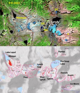
In 1984 there were nine glaciers spread across the Mount Daniel-Mount Hinman complex. You could traverse from one to the next with limited time off snow and ice. By late summer of 2023 only three glaicers remained. We monitored Daniel, Ice Worm and Lynch every years since 1984. Ice Worm no longer a glacier in 2023.
Mount Daniel is just south of Highway 2 and sits astride the Cascade Divide. A glacier complex across Mount Daniel and its neighbor Mount Hinman comprised of 9 glaciers covering km2 in 1984. This was the biggest cocentration of glaciers between Mount Rainer and Glacier Peak At the end of the summer 2023 melt season only three of these remain as glaciers, Daniels, Foss and Lynch Glacier. We began monitoring these glaciers along with Ice Worm Glacier in 1984. By 2005 Foss Glacier had deteriorated to the point that we stopped measuremets. It may not survive the summer of 2024. Ice Worm Glacier we monitored annually from 1984-2023, by the end of the summer in 2023 this was no longer a glacier. From 1984-2013 the loss was steady but slow, from 2014-2023 the ice loss from Ice Worm Glacier has been rapid. Ice Worm Glacier, Daniels Glacier,
Foss Glacier, Lynch Glacier.
| Glacier | GLIMS ID | Year Lost | 1958-1984 Area | 2015 Area |
2023 Area |
| Lynch Gap | G238804E47571N | 2015 | 0.291 | 0.01 | 0.005 |
| West Lynch | G238809E47571N | 2015 | 0.133 | 0.01 | 0 |
| Diptop | G238823E47586N | 2015 | 0.116 | 0.068 | 0.008 |
| East Daniels | G238831E47558N | 2015 | 0.043 | 0 | |
| Hinman Glacier | G238769E47576N | 2022 | 1.259 | 0.119 | 0.034 |
| Ice Worm Glacier | G238839E47559N | 2023 | 0.192 | 0.106 | 0.04 |
Shuksan Arm and Ptarmigan Ridge
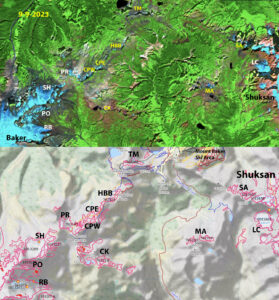
Glaciers on the ridge from Moutn Shuksan to Mount Baker that we observed to be active in mid 1980s, identified in GLIMS map below. Above Sentinel image from 9-9-2023. Glaciers that are no longer glaciers in yellow, seven of them including Mount Ann=MA, Shuksan Arm=SA, Coleman Pinnacle East/West=CPW/CPE, Camp Kiser=CK, Table Mountain=TM and HBB=Happy Bunny Butte. We still monitor each year Lower Curtis, Rainbow and Sholes.
The two most prominent mountains of the North Cascades Mount Shuksan and Mount Baker are connected by a ridge from Shuksan Arm to Ptarmigan Ridge. We visited all the glaciers in this regions in the mid-1980s to decide which to monitor annually. At that time each of these had active crevasses and significant area of glacier ice. By the end of 2023 seven of the thirteen glaciers are gone. We continue to monitor Lower Curtis, Rainbow and Sholes Glacier in detail. Portals and Ptarmigan Ridge Glacier will likely disappear in the next few years.
| Glacier | GLIMS ID | Year Lost | 1958/84 Area | 2015 Area | 2023 Area |
| Camp Kiser | G238275E48809N | 1993 | 0.22 | 0.03 | 0 |
| Happy Bunny Butte | G238277E48834N | 2005 | 0.166 | 0 | 0 |
| Table Mountain | G238295E48850N | 2015 | 0.158 | 0 | 0.008 |
| Coleman Pinnacle | G238269E48826N | 2018 | 0.56 | 0.031 | 0.018 |
| Mount Ann | G238341E48818N | 2022 | 0.12 | 0.07 | 0.01 |
| Shuksan Arm | G238362E48838N | 2023 | 0.16 | 0.07 | 0.03 |
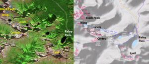
In 1984 and 1985 we visited five glaciers near Rainy Pass from Lyall Glacier in the east to Black Peak in the west. These were all located beneath peaks that provided some avalache accumulation, ouylimnes here in GLIMS at right. Today all five are gone in Sentinel image at right.
Rainy Pass
Rainy Pass is a drier region of the North Cascades. The glaciers we were looking at in the mid 1980’s were still on the west side of the divide, but the effective precipitation divide is further west. We traversed the high terrrain from Lyall Glacier, Lewis Glacier to Black Peak. At that time these glaciers were less active than other regionw we focussed on. They still had signficant size and evident active crevasses. We visited Lewis Glacier every year from 1984 until it was lost in 1992. By the end of 2023 all five had disappeared. All but Corteo fed into Granite Creek, we observed a 70% decline in August runoff from Lewis Lake after Lewis Glacier had disappeared. Detailed look at Lewis Glacier and Lyall Glacier.
| Lewis Glacier | G239204E48512N | 1990 | 0.17 | 0 | 0 |
| Lyall Glacier | G239253E48489N | 2005 | 0.25 | 0.016 | 0.004 |
| Black Peak | G239191E48525N | 2022 | 0.081 | 0.044 | 0.015 |
| Corteo Peak | G239152E48551N | 2022 | 0.168 | 0.06 | 0.03 |
Glacier Peak observations
Glacier Peak- A Century of Change
Kennedy Glacier
Milk Lake Glacier
White Chuck Glacier