Ackowledgements:
The following is the final draft of a paper that Bill Long had spent much of his career constructing from his extensive field experiences. This paper has been prepared by Mauri S. Pelto, Department of Geology, Nichols College, Dudley MA 01571. Any questions for further details or reprints should be directed to Mauri Pelto. I had the opportunity to go on six separate field expeditions with Bill Long in the North Cascades. During this time I saw many of the aforementioned moraines and soil profiles, but certainly not all. I had worked on several preliminary drafts with Bill Long and upon his passing in the spring of 1995 I was asked by his wife Kathleen Long to complete this paper.
Thanks to Kathleen for sharing Bill’s photo collection and old reports with me in preparing this paper. Thanks also to Stephen Porter who acted as Bill Long’s mentor on many occasions. Most of all I am thankful to have been able to spend time in the field with Bill and share in his joy and knowledge.
Summary
An examination of 48 cirque and valley head moraines between Mount Stuart and Bonanza Peak, North Cascade Range was made to identify the chronology of moraine emplacement. Nine moraines are mantled by Glacier Peak Tephra(11,250 BP) and represent a Late Wisconsin advance. Mazama Ash (7180 BP) mantles 25 moraines indicating a Late Wisconsin or Early Holocene advance. Fifteen moraines lack either tephra or ash, have immature vegetation and are neoglacial in age. Several alpine basins were largely ice free when Glacier Peak Tephra was deposited. Soil development on moraines mantled only by Mazama Ash was substantial in all five locations where soil profiles were completed. Both factors indicate a Late Wisconsin advance instead of an Early Holocene advance for North Cascade cirque glaciers that advanced.
Introduction
This study discusses an investigation of 48 cirque and valley head moraines along the crest and eastern slope of the North Cascades between chronology of cirque moraine formation during the Holocene epoch. Dendrochronology, tephrochronology and relative position were used in assigning age of emplacement for each moraine. The objective in examining such a large sample of moraines was to put in perspective the relative timing and magnitude of glacier advances since the peak of the late Wisconsin glaciation.
The interval of mild climate that followed the Wisconsin is the Hypsithermal. In the Pacific Northwest examination of pollen records have provided an age of approximately 10,000-5200 years for this period (Kearney and Luckman, 1983; Heusser, 1985; Barnosky et al., 1987). The North Cascade Range experienced extensive deglaciation during the Hypsithermal which was followed by a period of glacier rebirth and expansion, the Neoglacial (Porter and Denton, 1967). The Neoglacial has exhibited two distinct period of glacial advance. Pollen records indicate the early Neoglacial extended from 5000 to 2500 BP, and the youngest corresponding to the Little Ice Age of the last several hundred years (Denton and Karlen, 1973: Miller, 1969; Heikkinen, 1984).
In this study tephrochronology, soil profiles, and dendrochronology are used to determine or at least bracket the age of cirque moraine formation. Each geographic area is examined in turn to provide a spatial sense of the glacier variations. Previous studies have examined a few cirques in lesser detail. Regional mapping of Holocene glacier behavior requires a combination of both types of glacier mapping studies.
Beds of volcanic tephra resulting from eruption of volcanoes in the Cascade Range provide two important time horizons in the North Cascades, Mazama Ash (MA) which is 7180BP and Glacier Peak Tephra (GPT) approximately 11,250 BP (Mehringer et al., 1977). In the North Cascades the GPT consists largely of pumic and lapilli. Most of the GPT fell eastward of the summit reaching the northern and western edge of the study areas. The Icicle Creek drainage at the southern edge of the study area is south of the GPT zone. GPT has two widespread member, layers B and G (Mehringer et al., 1977; Porter, 1978). Both layers based on radiocarbon dating are approximately 11,250 BP in age.
Ash layer O was produced by eruptions at Mount Mazama. This layer has oxidized in the study area to an orange brown layer that is seen throughout the study are. This layer is comparatively thick and continuous in regions where soil development has occurred.
Field Observation
Icicle Creek Drainage
No GPT is found in the Icicle Creek Drainage because it is south of the GPT limit at Chiwakum Mountain (Figure 1-3; Table 1). Colchuck Lake at 1700m occupies the floor of a large cirque carved in the north flank of the Stuart Range. Early in the 20th century the level of the lake was artificially raised for water storage. In the fall at lake Drawdown a terminal moraine is exposed that bisects the lake at its narrow northern end. A bouldery left lateral moraine grades into the terminal moraine. On the lateral moraine the MA is present beneath a white sandy ash thought to be the 450 year old Mt. St. Helens Wn tephra (Mullineaux, 1974).
The upper Enchantment Lakes basin is at 2310-2350m and only 2km southeast of Colchuck Lake. At the south edge of these lakes is the rapidly disappearing Snow Creek Glacier (Pelto, 1993). Just beyond a fresh moraine (Brynhild) and 400m from Snow Creek Glacier is a weathered moraine, the Brisingamen. On and behind the Brisingamen both MA and Mt St.Helens Wn are found (Waitt et al., 1982). Mainly because the Brisingamen moraine underlies MA and is far upvalley of the late Wisconsin Rat Creek Moraine, Waitt et al(1982) concluded that it probably is early Holocene in age. However, as only a minimum limiting age is available for the Brisingamen, it could also represent a late Wisconsin advance.
Other pre-Mazama moraines in the Icicle Creek Drainage impound Eightmile lake, Lake Sylvester, Lake Margaret, Turquoise Lake, Chain Lakes, and one lies on the threshold of the Square-Wolverine Lake Cirque. Thus, Icicle Creek experienced a widespread late glacial (substantially after Rat Creek) or early Holocene advance. Because of the lack of GPT, the timing in this basin cannot be determined more accurately using tephra. No evidence of radiocarbon datable material was seen in any of the moraines. This is not surprising given the certainly barren bedrock and talus environment that would have existed during the late glacial-early Holocene period. A series of soil stratigraphic sections were exposed on the Lake Margaret moraine. Soil development between glacial material and MA is substantial ranging from 10-30cm. This suggest moraine emplacement long before MA deposition.
The Brynhild Moraine in front of Snow Creek Glacier is a conspicuous unvegetated moraine belt named the Brynhild. Brynhild bisects one of the Enchantment Lake’s at 2350m. This moraine is almost barren of lichen and is devoid of tephra, ash and soil. The above suggests that this moraine is no more than a century old, and this is corroborated by observations of Snow Creek Glacier in contact with the moraine (Rusk, 1924). There are also conspicuous fresh moraines located just beyond the edges of Colchuck Glacier, and all three glaciers on the north side of Mt. Stuart. The lack of lichen and vegetation on these four moraines indicate that the Little Ice Age advance was the most extensive of the Neoglacial period in Icicle Creek valley.
Chiwakum Mountains
A well developed right lateral moraine of the Chiwakum Creek Glacier comparable in age to the late Wisconsin Rat Creek moraine lies 90m above the west end of Chiwakum Lake. The type moraine of the latest Wisconsin glacial episode is the Larch Lake Moraine 8km upvalley from the terminal moraine of Rat Creek age, at the head of the Chiwakum Creek Valley (Long, 1989). The Larch Lake Moraine is a multiple terminal moraine that reaches an altitude of 1735m that is mantled by GPT. A GPT layer underlies a thick silty ash layer in a surface locality behind the innermost Larch Lake Moraine.
A stratigraphic cross section was obtained in the wet meadow inside the Larch Lake Moraine. The base of the section in in dark gray lacustrine silt, the deposit of a small lake formerly dammed by the moraine. The silt is overlain by 30cm of tephra consisting of yellowish brown and brown pumice lapilli up to 0.8cm in diameter(GPT). The GPT is covered by 43cm of dark gray sand and gravel and 30cm of black sandy organic sediment. Above the sand is 70cm of strong orange to yellow-brown silty ash (MA) capped by about 30cm of fine loamy sand laced with roots. The unusual thickness of the volcanic ash layer is most likely due to fluvial reworking and concentration of the ashes. Because the Larch Lake Moraine lies behind the Rat Creek Moraine of Late Wisconsin age and has GPT on and behind it, the moraine was built sometime before 11,250 BP.
In the cirque that holds Grace Lake is a well defined end moraine that reaches 1860m. MA was found at the east end of the left lateral moraine, but no GPT is present. A MA mantled moraine also dams Lake Brigham at 1780m.
As described by Merrill (1966), a moraine impounding Cup lake at 1965m lies in the highest cirque in the Chiwakum Valley. The Cup Lake Moraine is exceedingly fresh and is devoid of soil and vegetation. MA is absent on the moraine but is present on the steep slope immediately beyond it, indicating a Neoglacial emplacement probably during the LIA. A small cirque with a small amount of glacier ice is located above Upper Grace Lake (2105m). Approximately 125m beyond the existing ice are two moraines. Both moraines lack MA and are Neoglacial in age. The slope of the outer moraine is stable and has considerable alpine vegetation suggesting an early Neoglacial advance (5000-2500 BP). The slope of the inner moraine is unstable and unvegetated indicating a LIA advance.
In Chiwakum Valley evidence for a late glacial advance after 13,000 BP (Rat Creek age) and before 11,250 BP is exhibited in the Larch Lake Moraine. Two additional moraines of pre-Mazama age either early Holocene or late glacial also exist at Grace Lake and Lake Brigham. Two of the three existing Neoglacial cirque moraines date from the LIA, indicating that the LIA was the most extensive ice advance of the Neoglacial in Chiwakum Valley.
Stevens Pass
A Rat Creek age moraine occupies Stevens Pass at 1240m on the Cascade Crest at the head of Nason Creek (Porter, 1978). No GPT has been found on the surface of the moraine. GPT is seen about 10km downvalley suggesting that the upper valley was still ice covered at the time of the Glacier Peak eruption. A moraine overlain by MA lies near the head of Smith Brook at 1225m, 6km north of Stevens Pass. These two moraines occupy similar positions in upper valley reaches, have similar morphology and weathering characteristics and lie at almost identical altitudes; hence, the moraines are regarded as correlative in age, late glacial.
Surprise Lake is impounded behind a bouldery, completely intact, MA covered terminal moraine. Two recessional moraines covered with MA descend to the lake from a prominent right lateral moraine. This lateral moraines is more than 2km long. Along Glacier Lake the lateral moraine is double crested, and between the crest is a small narrow lake. Three bouldery moraines or protalus ramparts lie on the floor of the Surprise Creek valley-head cirque well above Surprise Lake. The outer two moraines underlie the MA, the inner one is ash free and Neoglacial in age.
Snow Creek is a tributary to Rainy Creek which flows northward into the Little Wenatchee River. Abundant GPToccurs in Snowy Creek valley to about 1090m but none was found in the upper 2.7km of the valley, suggesting that the upper valley was still ice covered at the time of the Glacier Peak eruption. The well formed Snowy Creek cirque on the west side of Nason Ridge has a moraine at the cirque threshold mantled with MA. The Crescent Creek Cirque on the east side of Nason Ridge has a late glacial moraine that underlies GPT.
Mount Daniel
Glacier crowned Mount Daniels lies on the Cascade Crest 21km south of Stevens Pass. On the east side of Mount Daniel the former Hyas Creek Glacier reached an altitude of 1675m terminating west of Peggy’s Pond. The terminal moraine is covered by MA. Several soil profiles were completed on this moraine. Each profile showed substantial organic rich soil horizons from 7-25cm in thickness between the late glacial material and MA. The area has been ice free since MA and soil development suggests considerable time between moraine emplacement and MA deposition. A well defined lateral moraine 10m high descends to the closed terminal moraine behind which are two recessional moraines emanating from the lateral moraine. Behind each moraine is a small pond. The moraines have a well developed soil and a thick turf. Each of these moraines is overlain by MA.
At 1690m a 3m high recessional moraine lacking volcanic ash, bears a 10cm cover of soil and immature alpine vegetation. The oldest tree cored on this moraine was a 6m alpine fir, that began growing more than 110 years ago, suggesting moraine formation during the LIA. The innermost moraine is 100m upvalley of the LIA maximum moraine and 0.5km down-valley from the existing Hyas Creek (Ice Worm) Glacier. The moraine is very fresh and devoid of soil. During the last 20 years the first alpine fir seedlings have taken hold. This moraine is less than a century old.
The moraine of the maximum Neoglacial advance of Lynch Glacier on the north side of Mount Daniel. lies against Dip Top Peak. This terminal moraine descends 100m both to the east and west out of the Pea Soup Lake Basin (1900m), indicating that the former Lynch Glacier drained down both sides of the Cascade Crest. This moraine is fresh lacking any soil or alpine vegetation. This moraine was still ice cored as late as 1984 and is from the LIA. Beyond this moraine MA is found in the cut bank of several drainage channels. Thus, the LIA advance was the largest of the Neoglacial for Lynch Glacier. Lynch Glacier receded out of Pea Soup Lake Basin in 1983. From air photo mapping Lynch Glacier had shrunk from 0.8km2 in 1955 to 0.5km2 in 1992 (Pelto, 1993). Daniels Glacier has a distinctive LIA lateral moraine and a MA mantled moraine in the cirque basin immediately below the current glacier. On Mt. Daniels the maximum Neoglacial advance on all three glaciers occurred during the LIA.
Entiat and Chelan Mountains
With the exception of the headward 3km of the Entiat River Valley, GPT was found throughout the Entiat drainage basin, indicating that the Chelan and Entiat Mountains were largely deglaciated by 11,250 BP. GPT is traceable upvalley to a well defined moraine between 1615m and 1675m. GPT and MA were not found on the surface of the moraine, but is found immediately beyond the moraine, indicating a Neoglacial age emplacement. This outer moraine has good soil development and well established alpine vegetation. Just upvalley is an exceedingly bouldery LIA moraine belt lacking soil and overlaps the upvalley end of the older moraine at 1675m.
Pumice can be traced to upper Ice Lake Cirque. Within the cirque thick pumice deposits are found behind a fresh boulder moraine, and GPT is found within the moraine which overlies GPT and MA. This moraine lacks soils and lichen development and is from the LIA.
The Choral Lake cirque at 2195m is 10km east of the Upper Ice Lake cirque. The Choral Lake cirque also must have been ice free from GPT to the Neoglacial, since the rubbly moraine impounding the lake overlies MA and contains abundant GPT.
Chronologic relations between the final late glacial advance of alpine glaciers and the GPT are see in the west-facing Carne Mountain cirque (Beget, 1984). On the Carne Mountain cirque threshold at 1875m is a large terminal moraine up to 5m high. The moraine contains blocks of gneiss from Carne Mountain and is buried under GPT. This basin remained ice free after the Glacier Peak eruption.
Cow Creek Meadow at 1555m occupies the flat floor of a cirque carved in the north side of Rampart Mountain. The meadow is fronted by a moraine that lies 600m north of the cirque headwall. Like the Carne Mountain cirque, Cow Creek Meadow and its moraine are buried by GPT and date to a late Wisconsin advance.
A well defined bouldery protalus rampart lies at 1950m on the north side of Milham Pass at the head of Emerald Park Creek. The deposit underlies GPT, again indicating that most cirques in the Chelan Mountains have been ice free for more than the last 11,250 years.
The Entiat River provides evidence that the LIA advance was the most extensive of the Neoglacial and the most extensive since the GPT in Ice Lake and Choral Lake cirques. In the Entiat Cirque the Neoglacial advance was slightly more extensive.
Glacier Peak. Pear Lake at 1465m is dammed by a bouldery moraine and drains subsurface through the moraine. GPT was not found on or behind the moraine or at Top Lake 1km east of Pear Lake. This suggests that this area was ice-covered at the time of the Glacier Peak eruption. MA is abundantly exposed throughout the Top Lake and Pear Lake area, indicating glacier disappearance by this time with no Neoglacial rejuvenation.
Lyman Lake and Dome Glacier Area
Lyman Glacier is the source of Railroad Creek a major tributary to Lake Chelan. The absence of GPT from the upper 9km of the Railroad Creek Valley suggest that it was still ice covered at 11,250 BP (Porter, 1978). Lyman Glacier ends at 1830m. One prominent moraine belts records the Holocene activity of this glacier. The outermost moraine has extensive alpine vegetation, larch and subalpine fir on it. The moraine overlies MA indicating that it represents the most extensive advance of the last 7000 years. This moraine is then likely a result of a Neoglacial advance. The outermost moraine merges with the in several
Upper Wenatchee River
Upper Chiwawa Basin at 1450m is at the head of the Chiwawa River 2km east of the Cascade Crest. On the north side of the basin, two well defied lateral moraines 15 to 20m high descend to the basin floor. One moraine was built by a glacier on the south side of Chiwawa Mountain, and the other by a glacier on the east side of Fortress Mountain. The moraines are densely vegetated and mantled by GPT. Like the outermost moraine in the Entiat Glacier cirque, the upper Chiwawa Basin moraines have good soil development. GPT was not found behind the moraine suggesting that the upper 2km of the valley was ice covered at the time of the Glacier Peak eruption.
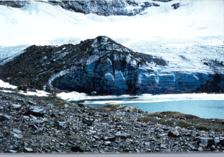
The Pear Lake cirque lies on the Cascade Crest 24km south of l locations and is even overrun in the center of the basin by a younger fresh moraine. This moraine dates from the LIA, has little vegetation and soil developed on it. Photographs by C.E. Rusk (1924) in 1906 show the glacier is still partially in contact with the LIA moraine. The oldest tree on the LIA moraine, determined from coring is 90 years old, suggesting a mid to late 19th century moraine stabilization. Soil profiles were completed 45m beyond the Lyman Glacier Neoglacial moraine on a small ridge. The base of the soil profile was a glacial till at a depth of 90cm, the nest 20cm was fine grained sand followed by 12-15cm of organic rich soil. Then MA ranging from 5-10cm in thickness. Above the MA is 20cm of organic rich topsoil. The thickness of pre MA soil development suggests a considerable time span from deglaciation to MA deposition, which suggests no early Holocene ice cover was as extensive as Neoglacial advances. The Neoglacial advance of Lyman Glacier was slightly more extensive than the LIA advance.
Dome Peak on the Cascade Crest 22km north of Glacier Peak has yielded a detailed Neoglacial record. No early Holocene advances were identified by Miller (1969). Miller (1969) examined the Holocene deposits in four valleys radiating from this massif and in two of these found MA on the valley floors immediately beyond moraines dated to the 16th century from dendrochronology. In three of the four valleys the most extensive advance was during the LIA. No evidence of earlier Neoglacial advance was recognized in front of LeConte Glacier or Dome Glacier. However, several overrun trees found in front of South Cascade Glacier, but well behind the LIA moraines, dated to 4700-4900 BP (Miller, 1969). A moraine beyond Chickamin Glacier was dated to the 13th century using dendrochronology of the oldest sub-alpine fir. However, this date is based on the a 600 year old sub-alpine fir. This age is beyond the expected life span of sub-alpine fir in this area and is suitable only as a minimum age and is more likely an earlier Neoglacial advance. This is the only potential evidence for a more extensive early Neoglacial advance than LIA advance around Dome Peak. As on Mt. Ranier reexamination of 13th or 14th century moraines appear to be from the early Neoglacial (Burbank, 1981).
Sawtooth Ridge
Sawtooth Ridge marks the boundary between the Chelan and Methow drainages and the crest lies generally above 2200m and culminates in several summits 2450m or higher. For 20km Sawtooth Ridge was almost entirely a nunatak above the Cordilleran Ice Sheet (Waitt, 1972). This is indicated by bedrock whalebacks aligned SSE and erratic boulders in the vicinity of 1890m in the Libby Creek Valley (Waitt, 1972). The headwaters of Libby Creek are defined by alpine cirques, Libby Lake at 2322m is the fourth highest lake in the Cascade Range. It is small, deep, circular and dammed by a broad moraine mantled by MA. A MA mantled moraine also impounds Upper Eagle Lake at 2167m 3km south of Libby Lake. No evidence of Neoglacial activity in seen on Sawtooth Ridge.
North Fork Skykomish River
The south facing Columbia Glacier cirque lies 13km west of the Cascade Crest. Below the current glacier extending most of the way to Blanca Lake are two left lateral moraines. The inner moraine is very bouldery and bears only scattered alpine flowers. The outer moraines supports a continuous alpine heather turf, with 3-5m high alpine firs. Both moraines date from the LIA. The LIA terminal moraine is preserved on the west side of the basin. Soil profiles on a small knob 20m beyond this moraine reveal an uninterrupted soil development (50cm thick) above the MA layer. Below the MA is 10-15cm of sandy organic soil, and then 60cm of glacial till on bedrock. The outwash plain beyond the LIA moraines is cut by several streams. The soil profile is well exposed in the stream banks. Thick organic rich soils lie both below and above the laterally continuous MA layer across an area of 0.2km2. Moraines at Silver Lake and Portal Peak also have MA immediately beyond the moraines, indicating no late Wisconsin or early Holocene advance in the basin.
Conclusions
In the North Cascade Range between Mount Stuart and Bonanza Peak abundant weathered cirque moraines are found that underlie the 7100 BP MA. On 8 moraines the 11,250 BP is found in addition to MA. MA is found alone mantling 25 moraines. These 25 moraines were emplaced prior to 7100 BP. There are 14 moraines that date to the Neoglacial period, 11 of these during the LIA. This indicates that in the North Cascades the LIA was generally the most extensive Neoglacial advance. On Lyman Glacier, Entiat Glacier and Hyas Creek Glacier LIA moraines and early Neoglacial moraines are somewhat overlapping, demonstrating the similar extent of early Neoglacial and LIA advances.
No GPT was found along the 70km stretch of the Pacific Crest Trail from Stevens Pass north to White Pass. This implies that the North Cascade Crest was still ice covered at 11,250 BP. The pre-Mazama cirque moraines near and along the Cascade Crest are devoid if GPT indicating that these moraines postdate GPT. Further east of the Cascade Crest in the Chiwakum, Entiat and Chelan Mountains numerous cirque moraines and cirque floors are mantled with pumice indicating that these cirques were ice free at the time of the eruptions. At least one valley head cirque has a moraine underlying GPT. These relationships imply that pre-Mazama cirque moraines were built just before, during and after the Glacier Peak eruption.
The question that remains is when were the 25 MA mantled moraines emplaced? Three lines of evidence have been compiled in this study to address this question.
- Ten cirques and high alpine valleys were ice fee from the time of GPT deposition to MA deposition (Upper Ice Lake, Choral lake, Cow Creek Meadow, Milham Pass, Crescent Lake, Saska Peak, Larch Lake, Carne Mountain, Upper Chiwawa Valley and North Fork Entiat Valley). This is strong evidence that Wisconsin alpine glacier retreat was largely completed by 11,250 BP, and that no substantial period of glacier formation and growth occurred prior to MA deposition.
- Soil profiles from four locations on or adjacent to four moraines mantled by MA indicate considerable thicknesses 7 to 30cm of organic rich soil developed between the late Wisconsin and MA deposition. This suggests that no advance had occurred within the 2000-3000 years between GPT and MA deposition.
- Observation of terminus behavior on 47 glaciers and mass balance annually on 8 North Cascade glaciers indicates a close similarity in behavior amongst glaciers throughout the range to significant climate change (Pelto, 1993 and 1996). All 47 North Cascade glaciers examined annually are currently retreating. The cross correlation coefficients for annual mass balance between the eight glaciers always exceeds 0.87 (Pelto, 1996). This argues against substantial local advances in the North Cascades.
The conclusion drawn from this data is that the early Holocene or late Wisconsin emplacements represent a minor readvance of existing late Wisconsin glaciers, not a later early Holocene period of glacier growth.
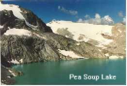
Table 1. Data on the age of cirque moraines. See Figure 1 and 2 for location. Tephra GPT=Glacier Peak Tephra, MA=Mazama Ash. LW=Late Wisconsin, LIA=Little Ice Age, NEO=Neoglacial, EH=Early Holocene
Map Cirque Basin Moraine Cirque Distance Tephra Age
No. Altitude Aspect to Crest
(km)
Icicle Creek Drainage
- Enchantment Lakes 2315 NE 40 E MA on, behind EHLW
- Colchuck Lake 1700 N 37 E MA on EHLW
- Lake Ann 1875 NW 28 E MA on EHLW
- Lake Sylvester 1905 W 14 E MA on EHLW
- Turquoise Lake 1665 E 5 E MA on EHLW
- Lake Margaret 1645 NW 13 E MA on EHLW
- Chain Lakes 1705 NW 8 E MA on EHLW
- Square Lake 1555 E 1 E MA on EHLW
- Little Eight Mile 1340 E 35 E MA on EHLW
- Colchuck Glacier 1900 N 37 E LIA
- Snow Creek Glacier 2350 NE 40 E LIA
Chiwakum Mountains
- Larch Lake 1768 N 12 E GPT on, behind LW
- Lake Grace 1860 NW 13 E MA on EHLW
- Lake Brigham 1775 NE 15 E MA on EHLW
- Upper Grace Lake 2135 N 14 E MA in front LIA
- Lake Charles 1915 NE 15 E MA in front LIA
- Cup Lake 1965 NE 11 E MA in front LIA
Nason Creek Drainage
- Crescent Lake 1705 E 10 E GPT on LW
- Lake Valhalla 1470 SE 0 MA on, behind EHLW
- Lake Susan Jane 1400 N 0 MA on, behind EHLW
- Surprise Lake 1570 N 0 MA on, behind EHLW
Mount Daniel
- Peggy’s Pond 1675 SE 2 E MA on, behind EHLW
- Hyas Creek Glacier 1720 E 2 E LIA
- Daniel Glacier 1495 NE 1 E MA in front NEO
- Lynch Glacier 1890 N 0 MA in front LIA
Chelan and Entiat Mountains
- Entiat Glacier 1615 E 13 E GPT in front LW
- North Fork Entiat 1980 NE 28 E GPT on LW
- Cow Cr. Meadow 1540 N 30 E GPT on LW
- Milham Pass 1950 N 22 E GPT on LW
- Saska Peak 2135 NW 23 E MA on EHLW
- Choral Lake 2195 NE 27 E GPT under LIA
- Entiat Glacier 1660 E 13 E MA in front NEO
- Upper Ice Lake 2195 NE 12 E GPT under LIA
- Carne Mountain 1875 NW 14 E GPT on, behind LW
Railroad Creek Drainage
- Lyman Glacier 1815 N 4 E MA in front NEO
- Isella Glacier 2000 S 7 E MA in front LIA
- Martin Peak 2040 E 13 E MA in front LIA
Upper Wenatchee River
- Snowy Creek 1400 NW 8 E MA on EHLW
- Upper Chiwawa 1450 E 5 E GPT on LW
- Pear Lake 1465 E 0 MA on, behind EHLW
Sawtooth Ridge
- Upper Eagle Lake 2165 E 45 E MA on EHLW
- Libby Lake 2320 E 46 E MA on EHLW
- Star Lake 2185 E 40 E EHLW
- Horseshoe Basin 2135 E 41 E MA on EHLW
North Fork Skykomish
- Columbia Glacier 1280 SW 13 W MA in front LIA
- Silver Lake 1300 E 19 W MA in front EHLW
- Portal Peak 1735 NE 5 W MA in front EHLW
References
Barnosky, C.W., Anderson, P.M., and Bartlein, P.J., 1987. The northwestern United
States during deglaciation: Vegetational history and paleoclimatic implications. In:
W.F. Ruddiman and H.E. Wright (editors). Late-Quaternary Environments of the
United States. 2. The Holocene. Univ. of Minnesota Press, Minneapolis, MN,
109-127.
Beget, J.E. 1984. Tephrochronology of late Wisconsin deglaciation and Holocene
glacier fluctuations near Glacier Peal, North Cascade Range, Washington. Quat.
Res., 21: 304-316.
Burbank, D.W. 1981. A chronology of late Holocene glacier fluctuations on Mt.
Ranier, Washington. Arctic and Alpine Res., 13: 369-386.
Denton, G.H. and Karlen, W., 1973. Holocene climatic variations their pattern and
possible cause. Quat. Res., 3: 155-205.
Heikkinen, O., 1984. Dendrochronological evidence of variations of Coleman Glacier,
Mt. Baker, Washington. Arctic and Alpine Res, 16: 53-64.
Heusser, C.J., 1985. Quaternary Pollen records from the Pacific Northwest Coast:
Aleutains to the Oregon-California Boundary. In Pollen records of Late
Quaternary North American Sediments. 141-161.
Kearney, M.S. and Luckman, B.H., 1983. Postglacial vegetational history of Tonquin
Pass, British Columbia. Can. J. Earth Sci., 20: 776-786.
Long, W.A., 1989. A probable sixth Leavenworth glacial substage in the Icicle-
Chiwakum Creeks area, North Cascade Range, Washington. Northwest Science,
63, 96-103.
Mehringer, P.J., Sheppard, J.C., and Foit, F.F., 1984. The age of Glacier Peak tephra
in west central Montana. Quat. Res., 21, 36-41.
Merrill, D.E., 1966. Glacial geology of the Chiwakum Creek drainage basin and
vicinity. M.S. Thesis, University of Washington, Seattle.
Miller, C.D., 1969. Chronology of Neoglacial moraines in the Dome Peak area, North
Cascade Range, Washington. Arctic and Alpine Res., 1, 49-66.
Mullineaux, D.R., 1974. Pumice and other pyroclastic deposits in Mount Ranier
National Park, Washington. USGS Bull., 1326.
Pelto, M.S., 1993. Current behavior of glaciers in the North Cascades and their effect
on regional water supplies. Washington Geology, 21(2), 3-10.
Pelto, M.S. 1996. Annual balance of North Cascade Washington glaciers 1984-1994.
- of Glaciology, 142, 2-11.
Porter, S.C. and Denton, G.H., 1967. Chronology of Neoglaciation in the North
American Cordillera. Amer. Jour. of Science, 265, 177-210.
Porter, S.C., 1978. Glacier Peak tephra in the North Cascade Range, Washington:
Stratigraphy, distribution and relationship to late-glacial events. Quat. Res.,
10, 30- 41.
Waitt, R.B., 1972. Geomorphology and glacial geology of the Methow Drainage Basin,
Eastern North Cascade Range, Washington. Ph.D. dissertation, University of
Washington, Seattle.
Waitt, R.B., Yount, J.C., and Davis P.T., 1982. Regional significance of an early
Holocene moraine in Enchantment Lakes Basin, North Cascade Range, Washington.
Quat Res., 17, 191-210.
FIGURE CAPTIONS
Figure 1. Index map of North Cascades. Black areas indicate glaciers. Moraine locations indicated by dot and numeral (see Table 1).
Figure 2. Index map of North Cascades. Black areas indicate glaciers. Moraine locations indicated by dot and numeral (see Table 1).
Figure 3. Localities where airfall deposits of tephra erupted from Glacier Peak Volcano have been found.
Figure 4. Map or Mount Daniel glacier system showing positions of glacier margins between latest Pleistocene and 1990.
Figure 5. Little Ice Age moraines at Lyman Glacier.