Prologue
The North Cascades rugged, cold, gray cloaked peaks, then snowy summits shine forth on the occasional sunny day. Despite having the largest concentration of glaciers in the lower 48 states, no North Cascade glacier can be reached without significant effort. In Alaska, Europe’s Alps or Canada’s Rocky Mountains a number of glaciers can be reached by road or ski lift. Driving on any of the three highways that cross the North Cascades only occasional glimpses of a glacier are obtained. In contrast, standing upon a North Cascade peak a sea of snow-covered summits dominates your view. North Cascade glaciers are a world apart, remote yet vital to us.
The North Cascades of Washington extend from Snoqualmie Pass to the Canadian Border and in 1980 contained 750 glaciers. Today this number is dwindling, for example Spider Glacier, Lewis Glacier, Milk Lake Glacier and Lyall Glacier are gone. North Cascade glaciers attract our attention because of their beauty, power, and inaccessibility. But more importantly these glaciers store water. Lots of water, as much water as all of the states’ lakes, rivers and reservoirs combined. They are natural reservoirs and provide 25% of the North Cascade regions total summer water supply. During the dry months of June-September North Cascade glaciers release approximately 230 billion gallons of water each year. Today this water is fully utilized for irrigation, salmon fisheries, and power generation.
All too often we take our natural resources for granted. We plan on 230 billion gallons of glacier runoff each summer. From 1944 to 1976 this was a good bet. Today, after several decades of stability North Cascade glacier’s are in rapid retreat. Annual runoff is determined by annual precipitation for the most part. However, the timing is altered by the existence of glaciers. A glacier retains snowpack in the spring and early summer when streamflow is high and releases meltwater later in the summer when others sources of water are diminishing. Thus, glacier retreat raises spring snowmelt season flows and reduces low late summer flows. This is important for fall salmon runs and for later summer irrigation and hydropower demands.
Three lines of evidence indicate that most North Cascade glaciers are currently in a state of disequilibrium. The mean cumulative annual balance for the 1984-2023 period is -24 m w.e, which represents a net loss of ice thickness exceeding 26 m. This is a significant loss for glaciers that average 30-50 m in thickness, representing ~40% of their entire volume lost in four decades.
Annual longitudinal profiles on nine glaciers North Cascade glaciers confirm this volume change indicating a loss of -14 to -22 m in thickness (5.0-5.6 m w.e) between 1984 and 2017, agreeing well with the cumulative mean annual balance of -18 m w.e for that period. The change in glacier thickness on several glaciers has been equally substantial in the accumulation zone and the ablation zone, indicating no point to which the glacier can retreat to achieve equilibrium.
North Cascade glacier retreat is rapid and ubiquitous. All 47 monitored glaciers are currently undergoing a significant retreat or have disappeared in the case of three of them. Two of the ten glaciers where mass balance observations were begun, Spider Glacier and Lewis Glacier, have disappeared. This retreat on eight Mount Baker glaciers from 1984-2022, that were advancing in 1975 averages, 540 m.
The retreat is due to 25% less April 1 winter snowfall from 1946-2007and warmer summer temperatures (1.5 F rise beginning in 1985). In 1987, 1992,1993, 1994, 1998, 2001, 2003, 2004, 2005, 2006, 2009, 2014, 2015, 2018, 2021 and 2022 water shortages in the North Cascade region were due to drier winters, rapid spring snowmelt and smaller glacier area available to melt. A smaller ice cube when melting provides less water. These glaciers are also home to many macroinvertebrates most notably iceworms that live off of red snow algae. Their habitat is shrinking. Since 2008 a series of wet winter have led to more spring and summer streamflow.
Between 1978 and 1987 Lewis Glacier shrank from 90 to 17 acres in size. The summer of 1987 proved to be too much for the Lewis Glacier 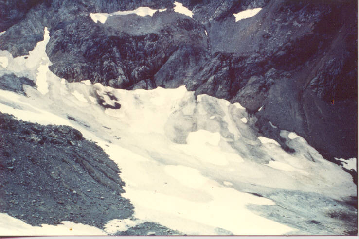 near Rainy Pass. By 1989 the Lewis Glacier was non-existent. To understand how climate warming is affecting our glaciers and how a potential greenhouse warming would impact North Cascade glaciers, we first must understand how glaciers work.
As director of the North Cascade Glacier Climate Project, since 1984, I have had the opportunity to visit 150 North Cascade glaciers. This website focuses on providing you with an understanding of how and why North Cascade glaciers behave as they do; and, how climate warming is affecting the glaciers and consequently our water supply.
Glaciers: An Introduction
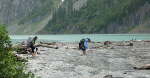
After ascending 2700′ in 3 miles through the deep shade of a virgin North Cascade forest, one emerges onto the ridgetop in an alpine meadow. A sign denotes the boundary of the Henry M. Jackson Wilderness Area, to the northeast Glacier Peak stands far above the intervening timbered ridges, and through the trees one mile to the northwest is Columbia Glacier. It is strange, standing in a forest looking directly across the valley at the Columbia Glacier at the same altitude as you are at. A glacier is a permanent body of snow and ice that moves. Glaciers form and endure where snowfall exceeds snowmelt. In this case Columbia Glacier is surrounded by high mountains blocking out the sun much of the day. The surrounding mountains also release avalanche snows that supplement the already high snowfall on the glacier, in addition, wind driven snow accumulates in the protected basin of Columbia Glacier. Avalanching, wind drifting and direct snowfall are the three sources of accumulation on glaciers. The 400 to 700 inches of snow the average North Cascade glacier receives, allows these glaciers to survive at comparatively low altitudes where summer temperatures are fairly warm.
By late April, the accumulated snow of the past winter on Columbia Glacier averages 25 feet in depth. The snow that does not melt is transformed, during the summer months, by partial melting and refreezing into small kernels of ice called firn. The firn is then buried by the next years snow, and during the following summer, if not exposed at the surface to melting, is altered by more passing meltwater. After surviving three or four summers the firn has been transformed into glacier ice. Meltwater melts part of the firn grains as it travels downward and sometimes add to the grains by refreezing.
A glacier is divided into two sections the ablation zone and accumulation zone by the annual snowline. The snowline indicates areas where snowfall equals snowmelt. Ablation (melting) exceeds snowfall in the ablation zone, whereas snowfall exceeds ablation in the accumulation zone. The snowline is easily identifiable by the change from white snow to blue glacier ice or gray firn. A glacier generally increases in thickness in the accumulation zone, the snows accumulating more and more. Below the snowline ablation dominates and thinning begins. Finally at the terminus the rate of glacier flow is equaled by the rate of melting and the glacier ends. In recent years some glaciers have not had a consistent accumulation zone. Without an accumulatiion zone the glacier cannot survive as event thea accumulation zone becomes an area of thinning.
Glacier Movement
As the snow and ice thickens movement begins, because the force of gravity overcomes the resisting friction of the rough bed at the base of the ice. The greater the weight of snow, firn and ice the greater the force of gravity acting upon the glacier. In the North Cascades a thickness of 50 feet on steep slopes, and 100 feet on shallow slopes is necessary to initiate movement. There are many small, thin and permanent snow patches in the North Cascades that are too thin to move and do not achieve glacial status.
To identify a glacier look for crevasses and blue glacier ice. Another test is to examine the color of the meltwater issuing from the questionable glacier, if the meltwater is relatively clear, then erosion is not occuring below the snowpatch, indicating no movement and it is not a glacier. If the meltwater is a milky blue, green or gray, this is due to the presence of glacial flour caused by glacier erosion and you are probably looking at a glacier. If possible you can peer under the edge of the snowpatch at the bottom of the ice and if the ice is grooved, then movement is occurring and you have a glacier.
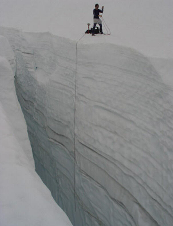
Glaciers move at different speeds depending on ice thickness, slope and bed roughness. Thick ice, steep slopes and a smooth bed lead to rapid movement. Glacier speed is not constant over the entire area of glacier; hence, crevasses occur. Crevasses are usually the focus of our attention on glaciers, because of the danger they pose. In the North Cascades these dark fractures in the surface of a glacier are typically 30 to 60 feet deep, seldom exceeding 100 feet in depth.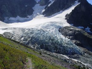
A crevasse occurs because of an increase in glacier speed. The acceleration literally pulls the surface apart, the downhill side of the crevasse is moving faster than the uphill side of the crevasse. The most common cause for an increase in glacier speed is an increase in slope. On the Lower Curtis Glacier there is a dramatic increase in glacier speed and hence crevassing as the glacier slopes suddenly steepens a short distance above the terminus. Crevassses are formed by differential glacier speed, usually due to a change in glacier slope; hence they tend to occur in the same place on a glacier. When a glacier flattens out crevasses are often compressed shut. Thus, a specific crevasse does not usually remain open as it is carried down glacier.
Icefalls are regions of intense crevassing caused by a sharp increase in slope. The resulting glacier acceleration causes heavy crevassing. Because of the comparatively rapid acceleration of the glacier, icefalls are unstable areas, having frequent avalanches. A prominent feature of icefalls are seracs. Seracs are towers of ice left standing between crevasses. The seracs often collapse causing numerous unpredictable avalanches during all seasons of the year. Icefalls on the Coleman and Lower Curtis Glacier are the most easily observed icefalls on North Cascade glaciers, each displays prominent seracs.
On slopes exceeding 55 degrees, glacier ice can no longer cling to the rock and will avalanche. Many North Cascade glaciers end on a steep slope releasing avalanches from the glacier front, examples are LeConte Glacier, Dana Glacier, Upper Curtis Glacier and Lower Curtis Glacier. These glaciers are spectacular to view from a distance, particularly during early spring when avalanching is heaviest, but are dangerous to set foot below. The avalanches end on gentler slopes, in some cases reforming into a glacier. This type of glacier is a reconstituted glacier, Lower Park Glacier on Mt. Baker, Johannesburg Glacier near Cascade Pass, and Lower Price Glacier on Mt. Shuksan are reconstituted glaciers.
That glaciers move makes them almost alive in our eyes. That this movement is unstoppable makes them daunting. There is no way to stop the inexorable motion of a glacier, in the Pamir Mountains of Russia an attempt was made to stop an advancing glacier by bombing it. This failed it was like bombing a sand dune, yes a large explosion occurred, but afterwards there was only slightly less snow and ice. In a similar fashion as glaciers slow down due to thinning from increased melting, we cannot offset this. On several glaciers in the Alps insulating blankets have been used to cover portions of several glaciers that are in ski areas.
Because glacier movement increases with increasing thickness a glacier tends to moves fastest near the snowline where it is thickest, and slowest at the terminus where it is thin. Movement has been measured on only a handful of glaciers in the North Cascades. The typical movement is 20-100 feet/year. The Columbia Glacier in the Monte Cristo area moves just several meters per year. In the mid 1930’s an avalanche of rock from Chiwawa Peak slid down onto the upper Lyman Glacier. In 1987 this debris reached the terminus. In 50 years this debris moved 800 m or 16 m/year. As climate warms a glacier will thin and move slower. In the icefall region above the terminus on the Lower Curtis Glacier the glacier is 50 m thick and is on an 18 degree slope. The result is a compartively rapid flow of 30 m/year from 1990-2000. The fastest moving glaciers in the North Cascades are the large glaciers on the flanks of Mt. Baker: Park Glacier, Deming Glacier and Coleman Glacier all reach velocities of 100 m/year in certain areas. This high speed is due to the high thickness and consistently steep slopes on Mt. Baker glaciers. At the slow end of the scale is Colonial Glacier and Whitechuck Glacier each moving less than 2m/year.
Glacial Geology
The movement of glaciers has sculpted the North Cascades into the jagged alpine range they are today. During the last 2.4 million years numerous ice ages have repeatedly blanketed much of the range with ice. The large valley glaciers carved out deep valleys, the expanded alpine glaciers carved out our alpine lakes.
Almost all alpine lakes in the North Cascades occupy cirque baisns excavated by glaciers. A cirque is a deep basin surrounded by high ridges in a horseshoe shape. These basins are created only by glacier erosion. The lip of the cirque, is the point from which stream emptying the cirque drains. The lip is near the former terminus position and has experienced little erosion; hence, the lip is higher in elevation than the area behind it where glacier erosion was high. Glacier erosion being highest at the snowline, results in the basin being deepest approximately halfway from the cirque lip to the headwall. Glacier erosion is also rapid at the headwall of the cirque, hence a cirque eats away at the mountain that is at its head.
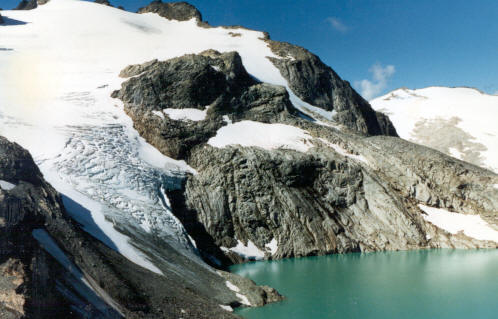
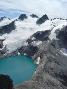
The result of cirques eroding opposites sides of the same ridge is a narrow, jagged ridge called an arrete. Ripsaw Ridge above Boston Glacier and Nooksack Ridge on the east side of Mt. Shuksan are two inhospitable examples. The Lower Curtis Glacier is eroding into the southwest face of Mt. Shuksan. Today the Columbia Glacier occupies a cirque at 4900 feet, while Blanca Lake at 3800 feet fills a cirque occupied by ice during the last ice age.
The unusual jade green color of Blanca Lake (see below) and many alpine lakes comes from glacier flour (clay sized sediment) suspended in the water altering the color from its normal blue. Glacial fed lakes and river typically have a blue green color that stems from rock eroded by glacier grinding of the base. This produces the fine glacier flour. Once a glacier seeks moving this fine sediment will be removed from the system and the lake or river color it feeds will change. Volcanoes erode more quickly and produce so much fine silt, sand and clay that rivers draining glaciers in volcanic terrain are more of a latte/cappuccino color. If this flows into a large enough lake a blue green color will still develop, but a small lake will not.
At the base of a glacier you can see the erosion occurring. Glacier ice in contact with the bedrock has innumerable small and large rocks frozen into the ice, these rocks act as cutting tools scraping away bedrock as the glacier slides over its base, creating vast quantities of glacier flour. This gigantic coarse grained “sandpaper” is the world’s most proficient at eroding our landscape. During the summer, meltwater at the glacier base carries away most of the sediment generated. During the rest of the year much of the sediment is frozen into the glacier base. Larger blocks of rock are often plucked out of the bedrock by a glacier. Imagine a 400 foot of ice scraping along its rock base, then it catches a small prominence, the downslope force applied to the prominence is sufficient to lift a section of rock out of its place. These blocks are carried in the basal ice of the glacier slowly being broken into smaller pieces as the boulder encounters other bedrock prominences. Near the terminus of a glacier you can usually see a small portion of the bottom of the glacier by looking under a lip of the glacier that is not resting firmly on the bedrock. You will see a basal ice layer that is filled with sediment and the ground surface will be covered with fine grained glacier flour and larger boulders As North Cascade glaciers retreat exposing bedrock, the bedrock is littered with sediment that melted out of the ice, this is called till and indicates the amount of debris a glacier carries. In some cases the material has been fluted. A flute is a straight narrow ridge of sediment that forms down glacier of a rock knob or large boulder, protecting the region below from erosion. This fluted till cannot be preserved unless the glacier melted in place as a stagnant ice body. Newly exposed bedrock is also covered with glacial striations. These scratches, are the source for most of the glacial flour. Glacial striations are elongated parallel to glacier flow. Striations seldom endure for more than a century.
The most distinctive features left behind by glaciers are moraines. In the North Cascades terminal, lateral and medial moraines can be observed.
Terminal moraines indicate the former terminus position of a glacier. Terminal moraines are formed by sediment continually carried forward by the glacier, much like a conveyor belt, and dumped at the terminus. Terminal moraines range from one to seventy feet in height. The largest moraines form over a long period and are some distance from present glacier termini, examples being Sahale Glacier near Cascade Pass, Entiat Glacier near Mt. Maude, ex-Lewis Glacier near Rainy Pass, Isella Glacier near Holden, and Boulder Glacier on Mt. Baker.
Lateral moraines are found on the sides of a glacier, paralleling glacier flow. These moraines are formed by sediment falling from the valley walls onto the glacier and by erosion of the valley wall by the glacier. Below the snowline this debris creates a band at the edge of the glacier. After the glacier melts away this band of debris is left as a ridge on the side of the valley. Prominent lateral moraines exist on Easton, Middle Cascade, Quien Sabe, Cool, Kennedy, Colonial and Honeycomb Glacier. The Railroad Grade on Easton Glacier is the best example. The retreat of Easton Glacier has left a very steep, unstable 100 foot high lateral moraine. The inside of the lateral moraine, which was in contact with the ice after the ice had melted, is steeper and more unstable than the outside of the moraine. As a result, vegetation development is often less on the inside of the moraine.
A medial moraine is a ridge or strip of debris in the middle of a glacier, formed when two branches of a glacier join, converting the lateral moraines of each glacier into a single medial moraine. Medial moraines are rare in the North Cascades because few glaciers consist of more than one branch. The Honeycomb Glacier east of Glacier Peak and Boulder Glacier on Mt. Baker have the best developed medial moraines.
Other glacial geologic features common to the Puget Sound region, such as kames, kettles and outwash plains are generally absent in the North Cascades, because the slopes are too steep for formation of these glacial features.
Mass Balance
In order for a glacier to develop snowfall must exceed snowmelt. For a glacier to survive snowfall must equal or exceed snowmelt. Mass balance is the amount of snow and ice accumulated minus the amount of snow and ice melted from the glacier during a hydrologic year (October-September). Like your checking account a positive balance is an excess of accumulation over melting (ablation). If ablation is larger a negative balance exists and the glacier will retreat. Mass balance is controlled by climate and in turn controls glacier behavior. To identify how a glacier will behave today and in the future mass balance must be known. This section focuses on how mass balance is measured and what the mass balance of North Cascade glaciers has been in recent years.
A quick estimate of glacier mass balance is obtained by observing snowline position. The snowline rises throughout the summer, its position at the end of the summer (September 30) is the annual snowline position. The annual snowline defines the percentage of a glacier’s total area that is in the accumulation zone. In the North Cascades, if avalanche accumulation is received, between 60 and 65 percent of a glaciers area must be snowcovered at the end of the summer for an equilibrium balance. If a glacier does not receive avalanche accumulation then 55 to 65 percent must be in the accumulation zone for equilibrium. In 1985, 1986, 1987, 1989, 1992, 1993, 1994, 1998, 2001, 2003, 2004, 2005, 2006, 2007, 2009, 2014, 2015, 2016, 2019, 2021 and 2022 less than 30 percent of the average North Cascade glacier remained snow covered at the end of September, indicating moderate negative balances causing glacier retreat.
The mean annual balance for the 1984-2022 period has been -0.6 m/a. The mean cumulative mass balance loss has been -24 m w.e, which is a minimum of 26 m of glacier thickness lost. North Cascade glacier average thickness ranges from 40-60 m. Thus, 30-40 % of the volume of these glaciers has been lost since 1984. Observations by the USGS at South Cascade Glacier indicate that since the mid-1950s, South Cascade Glacier’s cumulative mass balance was -25m, mean annual balance from 1956-1975 averaged -0.15 m/a , and from 1976-2012 averaged -0.75 m/a. The cumulative mass balance is trending more negatively, indicating that instead of approaching equilibrium as the glaciers retreat they are experiencing increasing disequilibrium with current climate.