Introduction
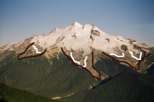
The impact of the Little Ice Age warming and the current global warming on alpine glaciers provides an analog for the magnitude and rate at which small alpine glaciers adjust to climate change. The 1.0o to 1.5oC post LIA warming resulted in extensive long term glacier retreat (Porter, 1986; Burbank, 1981). An examination of the terminus behavior of fifteen glaciers surrounding Glacier Peak, North Cascades Washington during the last century provides a synopsis of the varying impact of climate change on glaciers and the rate at which small alpine glaciers respond to climate warming.
It is a unique opportunity to view the long term behavior of many glaciers on the same mountain massif. This ensures that a representative picture of glacier response is obtained.
Terminus Observations
In the North Cascades since the end of the last ice age, three principal periods of alpine glacier advance have been identified using dendrochronology, lichenometry and volcanic ash layers. The Neoglacial (5000-2500) years ago, the Little Ice Age (1400-1850 A.D) and the recent advance (1944-1976) (Burbank, 1981; Miller, 1971; Hubley, 1956; Davis, 1988). The Neoglacial and Little Ice Age advances were of approximately the same magnitude with a snowline lowering of 100 to 150 m and substantial advances by all glaciers (Porter, 1986; Burbank, 1981). The recent advance was much smaller, with 50-60 percent of the North Cascade glaciers advancing (Hubley, 1956; Meier and Post, 1962).
In 1940 J.B. Richardson of the Forest Service photographed many North Cascade glaciers surrounding Glacier Peak. From 1946-1958 William Long, of the Forest Service surveyed many glaciers throughout the North Cascades (Long, 1955). From 1950-1955 Richard Hubley, University of Washington, completed the first aerial glacier surveys of North Cascade termini, noting the beginning of an advance on many (Hubley, 1956). The USGS in 1960 began an annual aerial photographic survey of North Cascade glaciers that continued up through 1979. In 1984 the North Cascade Glacier Climate Project began annual terminus observations on 47 glaciers, periodic terminus measurement on 60 more glaciers, and mass balance measurements on ten of these (Pelto, 1996).
The average retreat of Glacier Peak glaciers from the LIA to the 1958 positions was 1640 m. Richard Hubley noted that North Cascade glaciers began to advance in the early 1950s, after 30 years of rapid retreat. The advance was in response to a sharp rise in winter precipitation and a decline in summer temperature beginning in 1944 (Hubley, 1956; Long, 1955 and 1956). Ten of the fifteen glaciers around Glacier Peak advanced, including all of the glaciers directly on the mountains slopes. Advances of Glacier Peak glaciers ranged from 15 to 480 m and culminated in 1978. All 11 Glacier Peak glaciers that advanced during the 1950-1979 period emplaced identifiable maximum advance terminal moraines.
By 1984, all the Glacier Peak glaciers were again retreating. This retreat has been monitored by NCGCP. NCGCP determines terminus position change by measuring with a tape measure from fixed benchmarks to the glacier terminus at three locations. Each terminus measurement is made along the same azimuth approximately perpendicular to the glacier front. The average of the three measurements is the terminus change.
Glacier Peak Survey
Kololo Peak
![]()
Whitechuck Glacier retreated slowly from the LIA maximum until 1930. However, the glacier was rapidly thinning, preparing itself for rapid retreat. From 1940-1967 the glacier retreated rapidly across the flat lower basin that had been covered by thin ice at the beginning of the period. It was still a large glacier in 1967 with a northern and a southern branch.
In 1995 the southern terminus of the glacier ended in a new lake at 2030 m. The lake is not in evidence on the 1984 updated USGS topographic maps or in 1979 aerial photographs of the area.. This terminus has retreated 560 m since 1955, and 190 m since 1967. The central terminus of the Whitechuck Glacier ends in a lake basin at 1980 m. This basin was filled with glacier ice in 1967. In 1995, the new lake was 265 m long and still expanding. Total retreat of the central terminus since 1955 has been 410 m, 280 m since 1967. The northern half of Whitechuck Glacier extending up to Glacier Gap was still 0.9 km long rapidly melting, concave, stagnant ice in 1995. In 2005 the northern section of the glacier was gone. The main section of Whitechuck Glacier ending in the central and southern termini has a slightly convex shape and a long gentle slope (0.06) extending up to 2170 m, with many small crevasses. Total glacier area has decreased from 3.1 km2 in 1958 to 1.4 km2 in 2005. By 2024 the glacier area has declined to 0.5 km2. This glacier will not survive the current climate.
Suiattle Glacier C.E. Rusk in 1906 hiked right to the terminus of Suiattle Glacier, which is labelled Lion’s Paw in Rusk (1924). The glacier had retreated 1400 m since its Little Ice Age maximum and based on the lack of reported brush below the glacier, this retreat had occurred primarily in the previous 30 years. By 1940 the glacier had retreated another 900 m back to within 120 m of its current position. Suiattle Glacier retreated more from its LIA maximum than any other glacier in the area, probably due to the low slope of the Suiattle Valley from 1550-1700 m, down which the glacier had advanced. Rusk, noted the lack of any terminal moraine near the end of this glacier, this was unusual in his experience. In other words typically in this period a terminal moraine was not too distant from the current termini position. This glacier had already retreated so far that the terminal moraine was not only well down valley, but buried by aggrading sediments from the glacial stream. This retreat continued until 1967.
Between 1967 and 1979 Suiattle Glacier stopped retreating and began a small advance. Suiattle Glacier advanced 15-20 m during the 1970’s and by 1997 had retreated only 28 m from the advance moraine of the 1970’s. The retreat than accelerated with another 150 m by 2005. A total retreat of 480 m has occurred by 2024.
White River Glacier This glacier has experienced a smaller loss in area from its Little Ice Age maximum than any of the other Kololo Peak glaciers because most of the ice volume loss has been in thinning instead of terminus retreat. Post LIA retreat up to 1955 was 780 m.
From 1955-1967 White River Glacier had a stable though thinning terminus. In 1967 the glacier had two termini at the south end of two lakes. Today the two lakes fill these basins and the glaciers has retreated to the north end of the basins. The western basin is 260 m across and the eastern basin is 155 m across. Total retreat from 1967-1997 was 270 m and 160 m respectively for the western and eastern termini of White River Glacier. The termini of this glacier is steep but does not have a convex slope or significant crevassing. This glacier also tends to lose nearly its entire snowcover and thinning is pronounced at the top of the glacier where it used to meet the Honeycomb Glacier. This glacier will not survive current climate. By 2024 its area had declined to 0.45 km2.
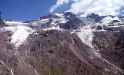
Honeycomb Glacier
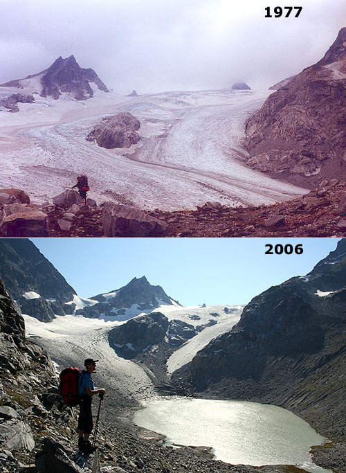
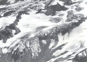
Honeycomb Glacier is one of the longest and largest glaciers in the North Cascades. It is currently 4 kilometers long and has an area of 3.4 km2. It has retreated 1.75 kilometers since its Little Ice Age Maximum. The glacier was an imposing site to Rusk (1924).
The 1967 photograph taken by Austin Post shows the glacier ending in a small lake. This lake was buried by ice in a 1955 Richard Hubley photograph. The terminus has retreated 458 m from the 1967 position. The glacier now ends in a new unnamed lake. This is a shallow lake that may eventually be filled in by glacier sediments. The terminus is flat and stagnant ending at 1680 m in the lake. Thus, the rapid retreat will continue, the glacier is still not close to acheiving a post LIA equilibrium.
Terminus retreat from the 1940 position is 700 m. Thus, glacier retreat from 1940-1967 averaged 9 m/year. Retreat was minor between 1967 and 1979. The retreat rate since 1979 has been greater than 18 m/year, with a total retreat of 450 m by 2004. The retreat from 1979-2024 has been 1125 m.
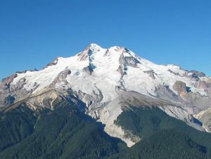
Glacier Peak
Kennedy Glacier
Kennedy and Scimitar Glacier were joined during the LIA descending the Kennedy Creek valley to an elevation of 1315 m. Retreat from the LIA maximum of 1000 m had occurred by the turn of the century. By 1946 the glacier had retreated an additional 700 m to an elevation of 1960 m. In 1952 the glacier was advancing rapidly. This advance continued up until 1975, the terminus having extended downslope 320 m to terminate at an altitude of 1785 m. By 1984 the terminus had begun to retreat. In 1994 the terminus had retreated 95 m, and by 1997 151 m. The retreat than accelerated with another 200 m of retreat by 2005. Total retreat from 1984-2024 has been 800 m.
Scimitar Glacier
Scimitar Glacier had the same history as Kennedy Glacier, retreating 1600 m from its LIA maximum by 1946. The first ascent of this glacier in 1956 occurred after Scimitar Glacier had begun advancing into a young alder thicket. The advance of 530 m ended in 1975 with the narrow, steep terminus at 1715 m. In 1994 the glacier had a steep, convex uncrevassed terminus. In 1997 this terminus is stagnant. Without any motion the retreat has been 98 m since 1979. The retreat has been slow because of the thickness of ice at the terminus. Retreat accelerated after 2005 and by 2024 retreat has been 650 m since 1984.
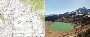
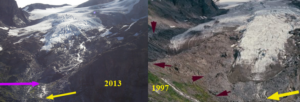
Milk Lake Glacier
This former glacier was on a ridge extending north from Glacier Peak and had a maximum area of 1.0 km2 at the LIA maximum. Retreat from the maximum was slow, as the glacier mainly thinned. In 1955 and again in 1967 Milk Lake Glacier filled the lake bed at 1840 m. By 1984 the glacier was clearly thinner, and a lake was in evidence around the eastern and southern edge of the glacier. By 1988 this lake had expanded greatly and the glacier had lost half of its area from the 1967 position. By 1997 the glacier had collapsed into the lake, leaving a narrow 50 m wide strip of thin fringing ice. The glacier is gone except for a few remanant ice patches. The area of the new Milk Lake is 0.175 km2. By 2005 Milk Lake glacier had disappeared.
Ptarmigan Glacier
Is a north facing glacier below Kennedy Peak. The glacier is a wide slope glacier. Retreat from the Little Ice Age maximum of 1050 m had occurred by 1940. The glacier continued to retreat slowly an additional 50 m by 1967. Between 1967 and 1975 the glacier advanced 75 m. Retreat since 1979 has been 190 m, with most of the retreat since 1997. By 2024 retreat has been 600 m.
Vista Glacier
This is the northernmost of the large valley glaciers on the east side of Glacier Peak. The glacier begins at 2475 feet beneath Kennedy Peak. The glacier during the LIA joined the Ermine Glacier and extended down to 1345 m. By 1900 when Asahel Curtis photographed this glacier it had retreated 1300 m. By 1946 the glacier had retreated an additional 600 m to its 20th century minimum at 1900 m. In 1955 the glacier had begun a slow advance that had ended by 1975 with a total advance of 105 m. By 1997 the glacier had retreated back to the 1946 position. The lower section of the glacier is thin and uncrevassed, and a rapid retreat is ongoing, reaching 700 m by 2024.
Ermine Glacier
Beginning at 2690 m this glacier extended down the Vista Creek Valley to 1345 m. The Vista and Ermine Glacier remained connected until the early 20th century. By 1940 the glacier had retreated to the top of a steep bedrock bench that marks the northern edge of the glacier, the bench is at 1960 m. In 1955 the glacier had begun to advance down this bench, but also push further northeast along the top of the bench. A spectacular icefall had formed by 1975 ,just above the terminus, caused by the descent of this steep bench. In 1987 the terminus had thinned but not retreated more than a few meters from the advance position. In 1992 the retreat became rapid, 108 m by 1997. Another 200 m of retreat had occurred by 2005. A total of 750 m by 2024.
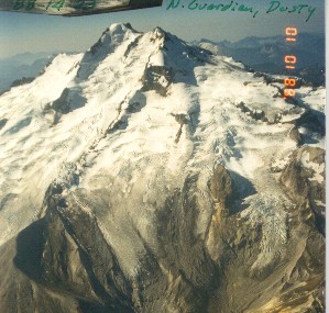
Dusty Glacier
This glacier has the widest most fearsome crevasses of any glacier in the North Cascades. The glacier descends from 2750 m to 2560 m before plunging over an icefall. The glacier levels out in a basin at 2325 m, before descending a second icefall to its current terminus at 1960 m. Dusty Glacier joined with the North Guardian Glacier during the LIA, separating during the 1930’s. During the LIA the glacier advanced to 1465 m. The retreat of this glacier by 1906 when Rusk observed it had been only 400 m. The glacier ended in a basin that was filled with ice, though much of the ice was stagnant. This basin became known as Recession Basin, for the ensuing rapid retreat up until 1946 when the glacier had retreated out of the basin and ended just north of Point 7523 feet at 2020 m. By 1955 advance was underway, an advance of 130 m had already occurred (Hubley, 1956). The advance ceased until 1967 when it began again, the glacier reaching another 150 m down into the upper part of Recession Basin at 1865 m. The terminus today is very active with extensive crevassing. In fact it is a true icefall. If avalanching off of the terminus down the steep slope did not occur, this glacier might maintain its current position. The glacier has retreated 400 m by 2005 and 700 m by 2024.
North Guardian Glacier
The North Guardian Glacier begins at 2630 m. The glacier is steep and extensively crevassed to 2200 m, but then has a gently sloped, uncrevassed nature to its terminus at 1960 m. The LIA retreat of 1500 m had ended by 1946 with the glacier terminating at 2020 m. The ensuing advance greatly increased crevassing. The net advance of 160 m was less than expected, probably because of the low slope basin at the terminus. Retreat has been mainly thinning, versus terminus meltbacke 1979. In 1997 the lower several hundred meters of the glacier had no crevassing. On the north side a separate tongue of the glacier had retreated to its 1946 position. The main terminus continued a slow retreat until 2004 and then accelerated. By 2024 total retreat has been 880 m.
Chocolate Glacier
This is the largest of the east side valley glaciers. Beginning at 3050 m it descends to 1800 m today. When Rusk (1924) first saw this glacier he noted that it presented a dramatic sediment covered front. Immediately above the terminus it was heavily crevassed and quite active, indicating a slow retreat. This glacier which he named Cool Glacier had retreated little from the alpine meadows fringing the south side of the glacier. The terminus had already retreated 400 m up the narrow valley by 1906 from its LIA. A retreat of 1380 m occurred between 1906 and 1946. The retreat was noted to be particularly rapid during the 1920-1940 period by Austin Post. Glacier advance had begun by 1950. An advance from 1946-1955 of more than 200 m had occurred (Hubley, 1956). The advance continued up until 1975 totalling 450 m. This was the largest advance of the Glacier Peak glaciers, probably due to the nature of the steep, narrow valley down which the glacier flows from 1960 m to the terminus. The retreat since 1975 has been 350 m. The current terminus at 1800 m is still the lowest of the east side glacier. Chocolate Glacier remains heavily crevassed and active to 1900 m. The lowest 300 m of the glacier are stagnant. From 1975 to 2024 retreat has been 1100 m.
Cool Glacier
This steep glacier is heavily controlled by the steep slope below the current terminus at 2100 m. The glacier cannot easily advance down this steep slope, as a result the advance during the 1955-1975 period was limited to 180 m. The LIA maximum was 1500 m beyond the current terminus. The LIA maximum at 1530 m was adjacent to the Suiattle LIA terminus. The retreat up the steep slope from 1600-1850 m was rapid and had been completed by the time of Rusk’s observations (Rusk, 1924). The retreat was then slow from 1910-1946 before a rapid advance occurred (Hubley, 1956). The advance reached its maximum by 1967, earlier than most becuase terminus avalanching precluded further advance. Since 1979 retreat has returned the south side of the glacier to its 1946 position, while north side is still 40 m in advance of the 1946 location. Total retreat by 2024 is 670 m.
Conclusions
The most important single variable observed for future behavior is the equlibrium line altitude (ELA: line above which snows remains year around). The ELA rose about 200 m at the end of the LIA generating the retreat of all of the glaciers averaging 1500 m around Glacier Peak. The adjustment to the post LIA warming took approximately 100 years on the Glacier Peak glaciers that have high slopes and comparatively rapid glacier flow, these glaciers drain Glacier Peak itself. The glaciers on the peak itself were near to equilibrium in 1946. The ELA then dropped nearly 100 m during the 1950-1975 period causing a small advance of 100-400 m on glaciers directly on Glacier Peak. This lowering was not enough to stop the retreat of four of the five Kololo Peak glaciers that are still adjusting to the post LIA warming. The ELA has since risen to 100-120 m again causing retreat of all glaciers. The glaciers around Kololo Peak and Milk Lake Glacier just north of Glacier Peak have all taken at least 150 years to adjust to the post LIA warming and except for Suiattle Glacier and Milk Lake Glacier have not reached a steady state even yet. Thus, a pronounced warming of more than 10C will take at least a century to fully respond to by these small alpine glacier.
The overall area of glaciers on Glacier Peak at the LIA maximum was 38.7 km2, by 1950 the area had dropped 23.7 km2, in 1975 the area had expanded to 24.9 km2, and in 2005 the area had reached a 20th century low of 21.6 km2.With even a maintenance of existing climate conditions an additional 20% of the glaciated area of Glacier Peak must be lost for equilibrium to be achieved.