There are many North Cascade glaciers that are disappearing. In 1993 I published the first report of glaciers I observed disappearing (Pelto, 1993). Below is a Table of North Cascade glaciers that we worked on when they were glaciers and have now disappeared. Images of selected glaciers lost around Washington State is below this table. Glaciers that have and are disappearing lack persistent accumulation zones. That is many years at the end of the summer there is no significant retained snowcover. This happens particularly on glaciers that lack avalanche accumulation, this applies to most slope glaciers. Pelto (2010) survival forecast method expanded on this point.
Glacier Name or Location |
GLIMS ID # |
Year Lost |
Initial Areakm2 |
2015 Areakm2 |
2022/23 Areakm2 |
Year of Initial Area |
| Lewis Glacier | G239204E48512N | 1990 | 0.17 | 0 | 0 | 1958 |
| Camp Kiser | G238275E48809N | 1993 | 0.22 | 0.03 | 0 | 1974 |
| David Glacier | G239009E47965N | 1993 | 0.072 | 0 | 0 | 1963 |
| Milk Lake Glacier | G238847E48152N | 1993 | 0.256 | 0.05 | 0 | 1984 |
| Spider Glacier | G239119E48165N | 2005 | 0.11 | 0.005 | 0.001 | 1984 |
| Arts Knoll | G238959E48433N | 2005 | 0.077 | 0.045 | 0.006 | 1958 |
| Lyall Glacier | G239253E48489N | 2005 | 0.25 | 0.016 | 0.004 | 1968 |
| Mount Watson East | G238440E48655N | 2015 | 0.13 | 0.01 | 0.005 | 1974 |
| Columbia Peak | G238641E47960N | 2015 | 0.058 | 0.036 | 0.021 | 1958 |
| Lynch Gap | G238804E47571N | 2015 | 0.291 | 0.005 | 1958 | |
| West Lynch | G238809E47571N | 2015 | 0.133 | 0 | 1958 | |
| Diptop | G238823E47586N | 2015 | 0.116 | 0.068 | 0.008 | 1958 |
| East Daniels | G238831E47558N | 2015 | 0.043 | 0 | ||
| Snow Creek Glacier | G239181E47474N | 2015 | 0.104 | 0 | 0.03 | 1957 |
| Snow Creek Glacier | G239186E47472N | 2015 | 0.118 | 0 | 0.01 | 1957 |
| East White River | G238914E48054N | 2015 | 0.2 | 0.075 | 0.008 | |
| Happy Bunny Butte | G238277E48834N | 2005 | 0.166 | 0 | 0 | 1974 |
| Table Mountain | G238295E48850N | 2015 | 0.158 | 0 | 0.008 | 1974 |
| Coleman Pinnacle | G238269E48826N | 2018 | 0.56 | 0.031 | 0.018 | 1974 |
| Mixup Peak | G238951E48449N | 2021 | 0.059 | 0.058 | 0.016 | 1958 |
| The Triplets | G238933E48463N | 2021 | 0.054 | 0.07 | 0.018 | 1958 |
| Cascade Peak | G238926E48464N | 2021 | 0.06 | 0.037 | 0.015 | 1958 |
| Forbidden Peak S. | G238940E48509N | 2021 | 0.147 | 0.066 | 0.03 | 1958 |
| Kyes Peak | G238660E47969N | 2022 | 0.087 | 0.068 | 0.044 | 1958 |
| Hinman Glacier | G238769E47576N | 2022 | 1.259 | 0.119 | 0.034 | 1958 |
| Lemah | G238702E47488N | 2022 | 0.126 | 0.041 | 0.01 | 1957 |
| Stuart West | G239090E47481N | 2022 | 0.092 | 0.036 | 0.016 | 1957 |
| New Morning Peak | G239154E48578N | 2022 | 0.076 | 0.056 | 0.024 | 1958 |
| Black Peak | G239191E48525N | 2022 | 0.081 | 0.044 | 0.015 | 1958 |
| Arriva Peak | G239152E48551N | 2022 | 0.168 | 0.06 | 0.03 | 1958 |
| Ice Worm Glacier | G238839E47559N | 2023 | 0.192 | 0.106 | 0.04 | 1958 |
| West Sulphide | G238376E48818N | 2023 | 0.07 | 0.05 |
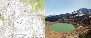
Milk Lake Glacier in USGS map and in 2005.
Lyall and Lewis Glacier in USGS map
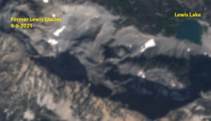
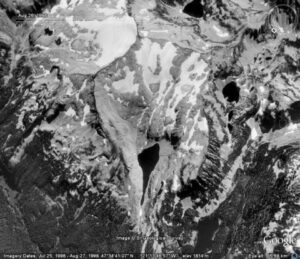
Former Lewis Glacier location in 2021 Sentinel 2 image, with 1988 and 1990 images from our field visits.
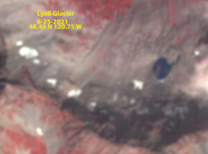
Former Lyall Glacier in 2021 Sentinel image
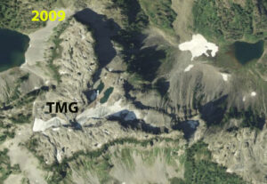
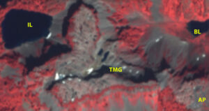
Table Mountain Glacier was a small but active crevassed glacier in 1985 when we first explored it. By 2009 it had lost most of its activity and size. By 2023 the glacier had fragmented into small inactive segments and is no longer a glacier.
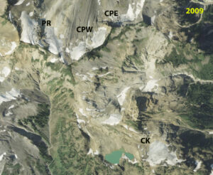
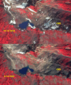
Camp Kiser Glacier is a glacier that was draped across a peak on the northern edge of the Camp Kiser area off of Ptarmigan Ridge. The glacier had crevassing and was active in 1990. By 2015 it was no longer active and by 2023 almost all relict ice was gone.
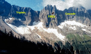
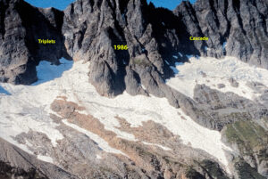
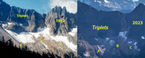
Triplets and Cascade Pass Glaciers were active and crevasses during our observations from 1986-2003. From 2021-2023 rapid are loss occurred and these are no longer glaciers.
2022 Sentinel image
Field survey image 2002
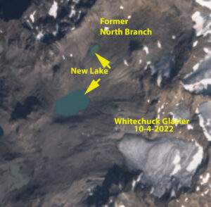
North Branch Whitechuck Glacier in October 2022 Sentinel image top, 2002 image looking downvalley in 2022 when it is gone. Bottom 1988 image with the north branch on the left side, no snow retained..
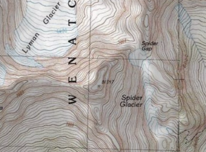
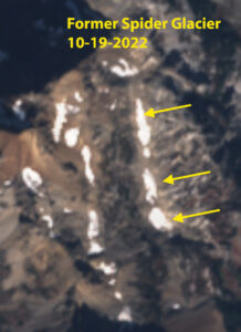
Spider Glacier in USGS map in 2007 and in Sentinel Image in 2022. This became a series of disjointed perennial snowfields in 2005.
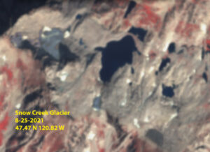
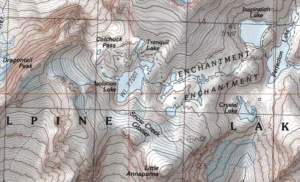
Snow Creek Glacier in USGS map and in 2022 Sentinel image.
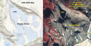
Hinman Glacier in 1958 USGS map and 2022 Sentinel image. The glacier went from the largest glacier between Mount Rainier and Glacier Peak to not existing by 2022. Above in 1998 Google Earth and 2009 image. There are a few small patches of remanant ice with areas of ~.01 km2
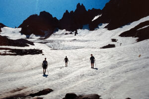
Ice Worm Glacier In 1986 William (Bill) Prater, who had made many first ascents in the area between 1944 and 1960, joined us in the field. Comparing images from these early visits with the current margin of Ice Worm Glacier indicated that there had little change in this glacier from 1944-1986. The mapped area in 1958 was 0.19 km2 (GLIMS, 2023), in 1986 we mapped the area at 0.18 km2. The glacier perimeter was surveyed in the low snow years of 2005 and 2015, identifying the glacier area to be 0.15 km2 and 0.110 km2, respectively. In 2015, the inventory for RGI noted an area of 0.106 km2. Annually, from 2021 to 2024, low snow cover allowed for mapping of the glacier perimeter during a rapid decline from 0.09 km2 to 0.03 km2.
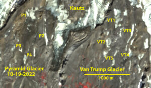
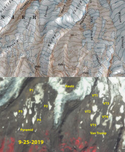
Van Trump and Pyramid Glacier on Mount Rainier no longer exist after the hot summers of 2021 and 2022 led to further fragmentation and area reduction. No single segment of ice exceeded 0.05 km2. Below is USGS map of region and 2019 image when the largest fragments still qualified as a glacier. By 2024 there was no single ice segment with an area of 0.025 km2
1959 aerial image of Anderson Glacier from Austin Post.
Anderson Glacier in 1990 Google Earth image above and 2009 image below. with lake indicating 1959 terminus green arrow, pink arrow 1990 terminus and red arrow bedrock knob below 2009 remanent.
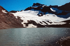
Anderson Glacier Olympic Range was a substantial glacier in 1959, that rapidly deteriorated after 1990 and was gone by 2009.
2022 Sentinel image showing four small fragments all less thab 0.04 km2.
2006 Google Earth image
Topographi map when in contact with lake
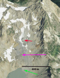
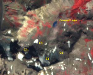
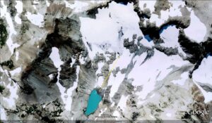
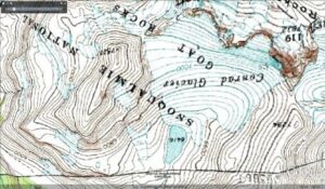
Conrad Glacier in Goat Rocks reaches Conrad Lake in the USGS map, by the time we mapped the glacier in 1993 it terminated 190 m from the lake, see images below, but was still a substantial glacier with an area of 0.2 km2. By 2006 it had retreated onto the upper slopes and by 2022 there was only four patches left none exceeding .0.04 km2.
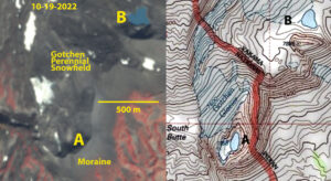
Gotchen Glacier on Mount Adams in USGS map and in 10-19-2022 Sentinel image with the largest remnant at 0.04 km2.
| Lyall Glacier, Frisco Peak-2005 | 5 East slope of Lago-Ptarmigan Peak | 2 North side Triplets and Cascade Peak-2023 |
| 1 Mixup Peak north side-2021 | 1 Arts Knoll North Side-2005 | 3 North side Frisco Peak |
| Lewis Glacier, Corteo Peak-1990 | 4 North side Cutthroat Peak | 4 North side Cutthroat Peak |
| Milk Lake Glacier, Fire Mt.-1993 | 2 North side Mount Gilbert | 2 North side Corteo and Black Peak-2022 |
| Spider Glacier, Chiwawa Pk-2005 | 1 West side Mount Arriva | 2 North side Indian Head |
| David Glacier, Mount David-1993 | 5 Entiat Range | 1 South side Ptarmigan Ridge-2015-Camp Kiser |
| Hinman Glacier, Mt. Hinman-2022 | 7 North side Mount Lago, Osceola and Carru | 3 North side Jonathan to Mount David Ridge |
| East White River Gl., Kololo Pk-2015 | 1 West Side Primus Peak | 1 North side Ptarmigan Ridge-2018- |
| Snow Creek Glacier, Little Annapurna-2015 | 1 East Ridge Mount Daniels-2022 | 1 Gap between Lynch and Hinman-2015 |
| North Branch Whitechuck Glacier, Kololo Peaks-2005 | 1 Northeast Mount Watson-2015 | 2 North side of Black Peak-2022 |
| 2 Sandalee glaciers | 1 South Side Sloan Peak | 1 Table Mountain Glacier-2015 |