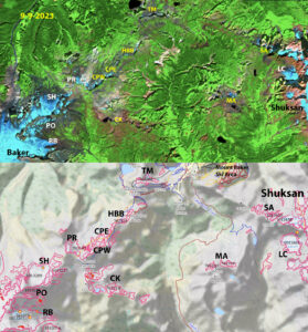
Glaciers we observe along the ridge from Mount Shuksan to Mount Baker. Six of these glaciers that existed in the 1980’s are now gone. CK=Camp Kiser, CPE/CPW=Coleman Pinnacle East/West, HBB=Hapyy Bunny Butte, TM=Table Mountain, MA=Mount Ann. We continue to monitor Lower Curtis=LC, Rainbow=RB, Sholes=SH and Ptarmigan Ridge=PR. Portals=PO and Shuksan Arm=SA nearly gone.
Ptarmigan Ridge
The trail from Artist Point out Ptarmigan Ridge to Coleman Pinnacle and Camp Kiser traverses alpine terrain with views of glaciers both adjacent to the trail and on nearby Mount Shuksan, Mount Baker and Bacon Peak. In 1985 our goal was to visit each of the glaciers near this trail from the Table Mountain Glacier to the Sholes Glacier where the trail terminates and identify which were worth monitoring annually. The area of these glaciers had not changed markedly since the 1974 mapping by the USGS and reported by GLIMS (Global Land Ice Measurements from Space) in Table below.
| Location/Glacier | GLIMS ID | 1974 | 2015 | 2023 | Date Lost |
| Ptarmigan Ridge | G239204E48512N | 0.56 | 0.1 | 0.065 | |
| Camp Kiser | G238275E48809N | 0.22 | 0.03 | 0 | 2005 |
| Happy Bunny Butte | G238277E48834N | 0.166 | 0 | 0 | 2015 |
| Table Mountain | G238295E48850N | 0.158 | 0 | 0.008 | 2015 |
| Coleman Pinnacle East | G238269E48826N | 0.156 | 0.017 | 0.018 | 2021 |
| Coleman Pinnacle West | G239204E48512N | 0.066 | 0.032 | 2023 | |
| Sholes Glacier | G238231E48814N | 1.188 | 0.877 | 0.78 |
Table 1. The area of glaciers in 1974, 2015 and 2023 as some either transitioned to perennial snowfields or disappeared entirely. The1974 and 2015 areas are from GLIMS, and 2023 area from the 9-9-2023 Sentinel 2 False Color Composite image.
In 1995 I was invited to stay with Austin Post at his Vashon Island home, he had been the USGS aerial glacier photographer from 1960-1979. He provided me with several thousand images of North Cascade glaciers from this period, that the USGS were disposing of. Below are some of these images.
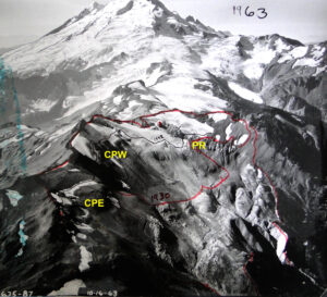
In 1963 the Ptarmigan Ridge glacier (PR) was connected to the Coleman Pinnacle West glacier (CPW). The Coleman Pinnacle East glacier (CPE) is shaded in this image. The red line was drawn by Austin Post to indicate the 1930 margin during my visit and the black line for 1992 I added that day as well.
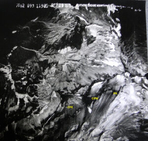
In 1970 this Austin Post aerial reveals the connected margin of Ptarmigan Ridge glacier(PR) and Coleman Pinnacle West glacier (CPW). Coleman Pinnacle East glacier (CPE) is also evident.
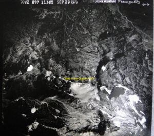
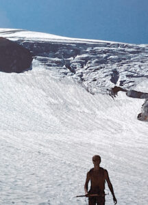
Camp Kiser is a region near the end of the trail. There is a gorgeous lake that can be seen from the trail, and over the ridge from the lake to the east was the Camp Kiser glacier seen here in 1970.
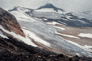
In 1985 Table Mountain glacier, Hoppy Bunny Butte glacier/perennial snowfield, and Camp Kiser glacier were thin, had limited crevassing and did not appear healthy. Coleman Pinnacle East and West glacier both had significant crevassing and extensive wind drift cornice development illustrating vitality. Ptarmigan Ridge glacier had advanced further downslope since the 1970 image and had a extensive crevassing both near the terminus and high up on the glacier.
Steep terminus of Ptarmigan Ridge glacier in 1985 that advanced in 1970s and was just beginning to retreat.
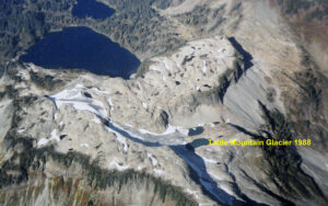
Table Mountain Glacier in 1988 terminating in two narrow lakes.
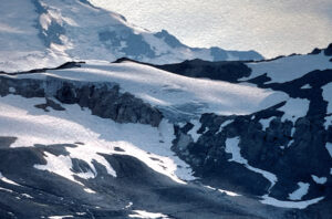
Ptarmigan Ridge glacier in 1990.
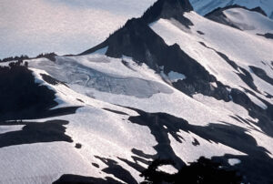
Coleman Pinnacle glaciers in 1990.
1992 View of Coleman Pinnacle East (foreground) and West (middle) in 1992 with low snowpack.
By 1995 all of these glaciers were experiencing significant declines. By 2009 it was clear that Table Mountain glacier, Camp Kiser glacier, and the perennial snowfield/glacier at Happy Bunny Butte were not going to survive long.
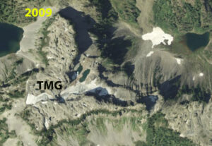
Table Mountain Glacier in 2009 Washington State NAIP imagery, still terminating in eastern lake. 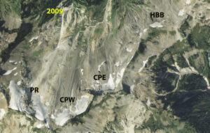
Happy Bunny Butte, Coleman Pinnacle East, Coleman Pinnacle West and Ptarmigan Ridge glacier in 2009 NAIP imagery. HBB too small to be a glacier and no crevasse. CPE closing in on threshold. CPW and PR separate glaciers.
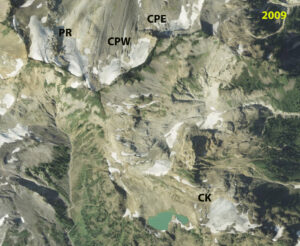
Coleman Pinnacle, Ptarmigan Ridge and Camp Kiser glaciers. Camp Kiser glacier still has significant size but no sign of movement.
A series of high melt years from 2003-2007 left Camp Kiser, Coleman Pinnacle east and Table Mountain Glacier on the brink of lost, while Happy Bunny Butte was already too small to be a glacier. Another series of high loss years from 2012-2015 eliminated Table Mountain glacier and Camp Kiser glacier.
We completed continuous mass balance observations across the North Cascades from 1984-2023. The most significant three year mass balance loss of this period was 2021-2023. This led to the loss of the Coleman Pinnacle East and West glacier. The glaciers are seen below in false color Sentinel imagery from 9-9-2023.
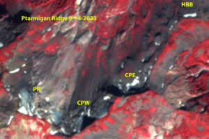
Coleman Pinnacle glaciers both have only relict crevassing in 2023 and are too small to be glaciers. Ptarmigan Ridge glacier still qualifies as a glacier. Below is an Oct. 2022 image from Wyatt Mullen of the Coleman Pinnacle East (foreground) West (midground) and Ptarmigan Ridge glacier (background). There are small relict crevasses in the Coleman Pinnacle glaciers. Both of these glaciers lost an additional 20% of their area in 2023 and are no longer glaciers.
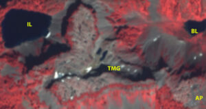
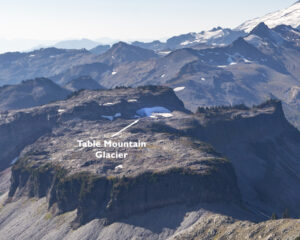
Table Mountain glacier by 2023 is a tiny patch of relict ice, note the two narrow lakes that in 1988 glacier terminated in. Below is the former Table Mountain glacier in Oct. 2022 image from Wyatt Mullen.
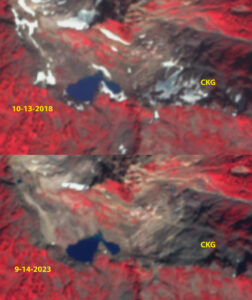
The relict ice that remained from Camp Kiser glacier in 2018 is gone by 9-9-2023.